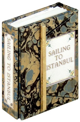
Sailing to Istanbul: A History in Maps
Riverside, CA: Bo Press Miniature Books, 2016. Hardcover. Pat Sweet describes herself as creating illuminated miniature books of curiosity, humor, and delight. She creates both miniature (under 3 inches) and macro-miniature (under 1 inch) books. She also makes miniature pocket globes, astronomical instruments, orreries, tellurions, and occasional oddities. “It’s Istanbul, not Constantinople now, but from the 11th century BCE and the foundation of the Thracian settlement known as Lygos, the world’s richest and best-defended city has stood at the meeting point of Europe and Asia. Sailing To Istanbul is a history of the city told in maps, from the earliest known depiction of the city in the Tabula Peutingeriana to the modern map of the Istanbul rapid transit system. The maps, both Eastern and Western, speak volumes about the city’s history, past, and future” (Pat Sweet). This open edition is bound in blue and gold Italian marbled paper covered boards with paper title labels to spine and front cover. This book features an overflap binding style that was inspired by a 17th century edition of Reis’s Book on Navigation. It includes twenty-eight tipped-in folding maps, ranging from the Nuzhat map of 1154 to the map of Constantinople by Christoforo Buondelmonte - the first map of the city itself. A map by the explorer and artist Piri Reis makes an appearance, and one of the loveliest maps, by an unknown hand, is from the reign of Sultan Abdul Hamid II. The most unsettling map, an Ottoman Empire census map from 1914, shows the proportional population figures of Muslims, Armenians, and Greeks. It also contains a fold-out timeline of the city, and a copy of Yeats’s famous poem ”Sailing To Byzantium,” from which this little map collection gets its name. In fine condition. Size: 2 3/4 x 2 3/8 inches. 74 pages. ARTB/090523. Fine. More